Maps — The coastal area of Pentland in 1950 and 2007
📄 Bài mẫu band 8–9
| Introduction | Paraphrase: hai bản đồ cho thấy dải bờ biển Pentland (biển ở phía đông) thay đổi thế nào giữa năm 1950 và 2007. |
| Overview | Overall: Pentland đổi từ vùng quê sống bằng nông nghiệp và đánh cá thành khu đô thị phục vụ giải trí, du lịch, mất nhiều đất tự nhiên; chỉ lighthouse, beach và main road còn nguyên. |
| Body 1 | Phía bắc main road: farmland → golf course (tây) và hai hotel (đông); fishing village → town centre with shops; fishing harbour → marina lớn hơn; coast track → coast road. |
| Body 2 | Phía nam: nửa bắc woodland → housing estate và caravan park (phía đông của nó), chỉ còn dải cây ở mép nam; phần trên sand dunes → car park, dunes còn khoảng một nửa; ngoài khơi đông bắc có wind farm ba turbine đối diện beach. |
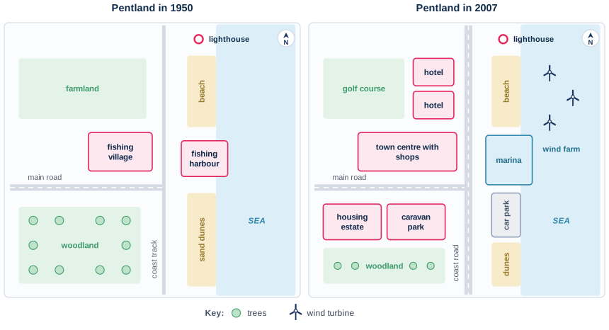
The two maps record the redevelopment of a stretch of coastline at Pentland, with the sea to the east, between 1950 and 2007.
Overall, Pentland was transformed from a rural community based on farming and fishing into a built-up area geared towards leisure and tourism, with a considerable loss of natural land. Only the lighthouse, the beach and the main road were left unchanged.
By 2007, the farmland north of the main road had given way to a golf course and, to its east, two hotels. The fishing village beside the junction had grown into a town centre with shops, while the fishing harbour just across the track had been converted into a larger marina. The coast track running north to south behind the shore had been upgraded to a road.
South of the main road, the northern half of the woodland had been cleared to make way for a housing estate and, to its east, a caravan park, leaving only a strip of trees along the southern edge. On the shore, the northern part of the sand dunes had become a car park, which reduced the dunes to roughly half their former size. A wind farm of three turbines had been erected offshore in the north-east, opposite the beach.
| geared towards leisure | hướng tới phục vụ giải trí |
| had given way to | đã nhường chỗ cho |
| had been converted into | đã được chuyển đổi thành |
| had been upgraded to | đã được nâng cấp thành |
| cleared to make way for | bị phát quang để lấy chỗ cho |
| roughly half their former size | còn khoảng một nửa diện tích trước đây |
| erected offshore | được dựng ngoài khơi |